Weathering and Erosion
Cycle of Erosion
The concept of cycle of erosion is one of the most important concepts in geomorphology. Put forth by W.M. Davis, this concept deals with the development of landforms under the influence of the agents of erosion. The cycle of erosion is that time in which a newly formed landform is reduced to a low featureless plain through erosion and deposition by agents of erosion.
Davis considered the landforms as dynamic and he stated that a landform is a function of structure, process and stage. The structure refers to the geological and morphological character of the landforms and includes the nature of the rocks, including the composition, structure and altitude etc. The process refers to the action of the agents of erosion and the term stage refers to the time element. According to this view of Davis the landforms once created by the geological forces of the earth are exposed to the process of erosion and they are sculptured by the process over a long period of time. The amount or degree of transformation in the original character of a landform will depend upon the time for which agents of erosion have been working over it.
Depending upon the degree of transformation of the original characteristics of the landform Davis has identified three stages in the cycle of erosion- the stages of youth, maturity and old age. Assuming a suddenly uplifted landform in an area of humid climate, the sculpturing work will be performed by running water or rivers. In the beginning of the cycle of erosion the said landform will be having rounded summits and the streams will flow through consequent valleys, following the original slope of land. The streams will tend to erode the entire area to the base level (the level up to which the streams can erode their valleys, i.e. the level of the sea). In the stage of youth the stream will have a high velocity and the energy of the stream will be utilised in deepening the valley thereby making the relief of the whole region sharper. However, most of the water divides will not be eroded in this stage.
During the stage of maturity the slope in the river channel would have been reduced thereby reducing the stream velocity. The process of valley deepening will slacken and that of valley widening will become more pronounced. The divides will be eroded giving them conical peaks and reducing their height from the sea level. This stage will be a protracted stage and by the end of this stage all the original surface will be eroded and lowered in height and the stream velocity will be progressively reduced.
The stage of old age is characterized by a very low degree of slope in the whole region and the landform will be reduced to a very low height from the sea level. The stream will reach its base level thus having no more capacity to erode and the entire landform will become a featureless plain with occasional raised areas representing the parts of the original landform which have escaped erosion due to their high resistance to erosion. The gently sloping plain thus produced has been called a peneplain by Davis and the occasional raised areas found in it have been named monadnocks.
Davis has also suggested the rejuvenation of the landforms which literally means to become young again. This implies that the base level is often changed before the entire landform is changed into a peneplain. The change in the base level may result from a lowering of the sea level due to the climatic or tectonic changes or the upliftment of the landform. In both these cases, the streams which might have been nearing their base level, will have to start eroding their valleys afresh to attain the fresh base level.
Davis has been often criticized for providing a standard cycle of erosion trying to explain the origin and sculpturing of all the landforms. His assumption of a rapid upliftment and the erosion proceeding on a stable landmass has also been criticized. His cycle concept has not taken into consideration the situation of simultaneous upliftment and erosion, which according to Penck, is most often the reality.
Penck has given his own version of the cycle of erosion and his major point of difference with Davisian cycle is concerned with the relationship between the rate of upliftment and erosion which Penck has considered. According to Penck, the rate of erosion is always dependent upon the rate of upliftment and he has suggested a number of cycles which suit various conditions of upliftment and erosion. However, unlike Davis he has not given a standard cycle of erosion explaining the evolution of landforms.
Although Davis has been criticized for his views on the cycle of erosion, his has been a pioneer attempt in this context and his ideas are still applied by geomorphologists, though in a modified form.
Landforms Made by Rivers
Rivers are important agents of erosion and the erosional capacity of a river is function of its volume and velocity. The landforms formed by erosion and deposition by rivers are called fluvial landforms. Corrasion and attrition are the major erosional processes in a river. Corrasion is the process of breaking rock fragments through friction action while attrition refers to mutual friction among the transported particles. The friction caused by the transported material on the rocks in called abrasion.
The erosional action of a river is a result of its tendency to lower the floor of its valleys to the level of the sea or the water body into which it flows. This lowest level to which a river can erode its valley is called the base level. V-shaped valleys, gorges and waterfalls are the major erosional landforms made by a river while the flood plains, alluvial (material deposited by streams) fans, alluvial cones and delta are the important depositiona! landforms made by rivers. Meanders and ox-bow lakes are also made by rivers in their journey through areas of flat terrain. The old alluvium in the flood plain of a river is called bangar and the new alluvium deposited near the stream channel in the flood plain is called the khadar. Landforms Made by Glaciers
Glaciers are slowly moving masses of ice. They have a tremendous erosional and transporting capacity. The process of breaking down of rocks by a glacier is called plucking. The material transported by a glacier is called moraine. The glaciers form a number of landforms through erosion and deposition. U-shaped valleys, cirques, cols, passes and hanging valleys are formed through erosion by glaciers. The depositional features formed by a glacier are the moraines and the outwash plains. Outwash plains are formed through the deposition of the material transported by a glacier, when the glacier melts. Sometimes the glaciers erode their valleys right up to the sea and such valleys may get drowned into sea. Such drowned valleys are called fiords. Norway is called the land of fiords.
Landforms Made by Winds
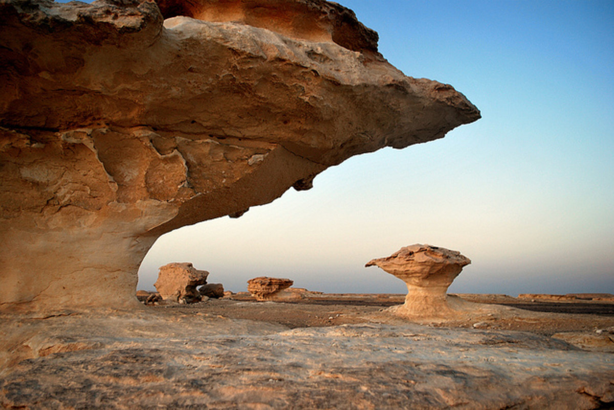
Winds are important agents of erosion in deserts where the soil is dry and the sand particles can be easily carried by winds. Removal of lose rock particles by winds is called deflation. The dust particles present in the air add to the process of abrasion by winds. The erosional capacity of wind is determined by the velocity of the wind and the amount of debris present in the air. The important landforms made through erosion by wind are deflation hollows, mushroom rocks, desert pavements, inselbergs and zeugens. The wind deposits the transported material when its velocity is reduced or when the matter transported by it is carried to the ground by rainfall. Sand dunes are the most important depositional features made by wind. A typical type of very large sand dune with a concave wind facing slope is called a barkhan. Loess plains are also formed through wind deposition. Hwang-ho Valley in China has very thick deposits of loess (wind blown dust of very fine particle size). The landforms made by winds are called eolian landforms also.
Landforms Made by Underground Water
Underground water flows very slowly and it cannot erode rocks only due to its mobility. It rather performs the action of erosion through the solution action. The underground water, therefore is an important agent of erosion in areas of soluble rocks such as limestone. Landforms made in the limestone rocks are called karst landforms, so named after the karst region of Yugoslavia where the best examples of such landforms are found in abundance. The major landforms made through erosion by underground water are the sink holes, dolines, underground caverns and karst lakes. The depositional landforms include the stalactites, stalagmites, drip stones and limestone veins.
Landforms Made by Waves
The erosional and depositional action of the waves is confined to the narrow coastal regions. The erosion by waves is a result of the physical force of the breaking waves and the force of the air trapped in the rock joints as the waves break on these rocks. Wave-cut platforms, cliffs, caves, bays, sea arches and stacks are the important landforms made by wave erosion. The most important features formed through deposition by waves include the beaches, sand bars, spits and the lagoons. A lagoon is a partly cut off part of the sea which is separated from the open sea by a barrier bar which cuts it off from the sea at the time of low tide when the bar is above the water. At the time of high tide the bar is submerged in the water and the lagoon is connected to the open sea. They are considered safe fishing areas. Lakes Chilka and Pulicut are lagoon lakes.
Weathering and Erosion
Weathering and erosion are the most important external forces which contribute to the process of gradation on the earth surface. Weathering refers to the physical and chemical break down of rocks under the influence of the elements of weather. Change of temperature and the action of water and atmospheric gases are the major causes of weathering. Breaking down of rocks into progressively smaller fragments without any chemical alteration in their composition is called mechanical or physical weathering. This is basically a result of expansion and contraction of the rocks due to temperature changes and increasing and decreasing volume of water at the time of freezing and melting. These processes widen the joints of the rocks and they start crumbling down in form of small particles. Mechanical weathering is an important process in the deserts, both hot and cold. In the cold deserts it is the freezing and thawing of water in the rock joints which is responsible for mechanical weathering. It is called the frost action.
In humid regions the rocks are exposed to moisture and in presence of water the atmospheric gases react chemically with the minerals in rocks. Thus processes like formation of oxides, carbonates, hydroxides etc. and solution of soluble minerals like salt etc. help in removing part of the constituents of rocks in solution. The remaining rocks thus start breaking into small fragments. This is responsible for a variety of chemical changes also in the composition of the rocks.
Plants and animals also contribute to the process of weathering. The roots of the plants widen the rock joints and when the plants die the rock break down into smaller fragments. Likewise, the animals also break the rocks by trampling on them or burrowing in them. This is called biological weathering. Some of the processes involved in biological weathering are chemical processes also. The decaying organic matter, e.g. produces humic acid which dissolves a number of minerals and thus helps in weathering of rocks. Soil formation is the most important result of weathering. It must be understood clearly that the process of weathering implies breaking down of rocks in situ, i.e. no transportation of the broken rock fragments is involved in this process.
The process of erosion on the other hand implies breaking of rocks and removal of loose fragments of rocks by agents which are mobile. Rivers, glaciers, winds, waves and underground water are the most important agents of erosion. All these agents operate in various types of regions, e.g. the rivers are important in the humid regions, the winds in the dry regions and the waves in the coastal regions. They remove the rock debris from the higher regions and deposit it in the low lying regions thus helping in planation or gradation. The process of removal of rock material from the higher areas is called degradation while the deposition of the rock debris in lower areas is called aggradation. The major processes involved in erosional work of various agents and the major landforms formed by them are listed below.

